60 Year Ride
This year, we celebrate 60 years of Cycle Club Bexley with a special anniversary ride to Whitstable and a seaside picnic.
The ride finishes at the Sea View Café which is open to purchase refreshments. There is a large, grassed area by the café on which we can gather for our celebrations. You can also bring a picnic and chairs etc. If you are riding why not get a family member to drive down to join in our celebrations, and they may even drive you home!!
The details below give times of trains back to Gravesend if you do not wish to ride back.
Welcome to the CCBexley Anniversary ride info sheet.
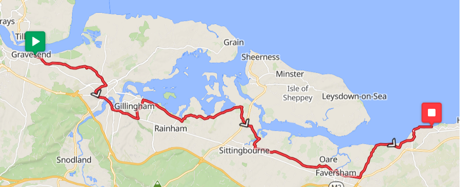
Date: Sunday 12th July. Distance 69km
Grand depart 10:00am prompt-ish from Milton Place car park (free parking on Sundays), Gravesend. The car park is accessed from Ordnance Road. – see figures 1&2
What3words – ///aims.cooks.salsa
Although if you fancy it… there will be a prologue depart at 9am from the post-box, Farningham to add an additional 16km to meet at Milton Place.
The route will leave the Gravesend area along the Rochester Road before heading down the Lower Higham Road, through Higham to Strood, over the Rochester bridge before meeting the short ride at Rochester Station after 14.6km at approx. 10:45. Leaving Rochester sharp at 10:55am.
Progressing through Chatham along main routes and up the only real climb of the day, Chatham Hill, through Gillingham before following the picturesque and quieter Lower Rainham Road, through Upchuch, Lower Halstow, Iwade, Kemsley, Sittingbourne, Teynham, Faversham, Seasalter and finally Whitstable.
The route will be available on ride with gps, please search CCBexley 60th where the route is available for download in GPX, FIT, TCX formats with cue sheets.
L’arrivee – The Sea View Café, Marine Parade, ETA would be approx. 1:30/2pm – see figure 3
What3words ///ladder.barn.crab
The return leg:
After having lunch, and spending time with those who drove, you can then catch the train to Gravesend station. (not sure if you must pay for bikes but train timings/ prices as follow:
Direct to Gravesend (54min journey) every hour at 51mins past the hour 14:51,15:51, etc.
Indirect to Gravesend (62min journey) every hour at 27min past the hour change at Rochester. Additional service at 58mins past the hour from 17:58 onwards.
Pricing from Whitstable station
Under £10 with advance booking and railcard will be in region of approx £8.10p – you are then fixed to your departure time.
Anytime advance single is £16.15
Anytime single on the day £24.30.
Start Location
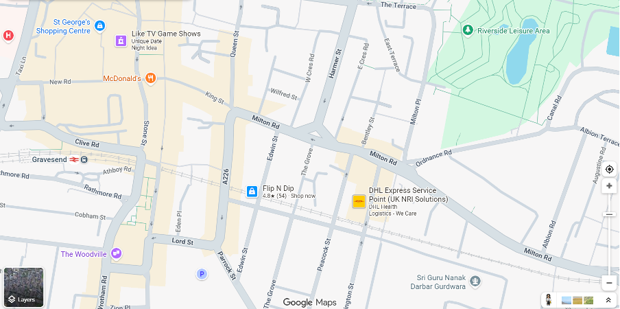
Figure 1 – Gravesend (station and Milton Place carpark)
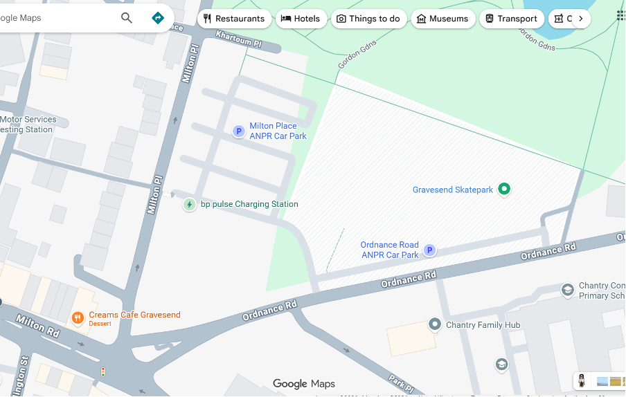
Figure 2 – Milton Place/ Ordnance Road Car Park – (Doesn’t appear to be any height restrictions for bikes on roof racks) PARKING IS FREE ON SUNDAYS
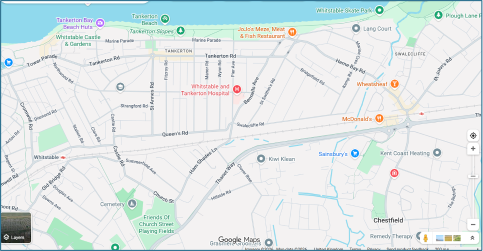
Figure 3 – Finish location at the Sea View Café at the top of Marine Parade.
Return stations shown Whitstable – 1.3 mile or Chestfield and Swaleclife – 0.8mile
| Ref | Type | Notes | Distance (km) From Start | Elevation (m) |
| Start | Start of route | 0 | 0 | |
| 1 | Right | Turn right onto Ordnance Road | 0 | 10.8 |
| 2 | Left | Turn left onto Milton Road | 0.09 | 14.4 |
| 3 | Straight | Enter roundabout | 1.82 | 15.6 |
| 4 | Straight | At roundabout, take exit 2 onto Lower Higham Road | 1.82 | 15.6 |
| 5 | Left | Turn left onto Lower Higham Road | 2.3 | 15.5 |
| 6 | Left | Turn left onto Chequers Street | 7.07 | 11.9 |
| 7 | Slight Right | Keep right onto Lower Rochester Road | 8.5 | 28.9 |
| 8 | Right | Turn right onto Lower Rochester Road | 9.39 | 29.8 |
| 9 | Sharp Right | Turn sharp right onto Brompton Farm Road | 10.57 | 36.3 |
| 10 | Slight Right | Turn slight right onto Brompton Farm Road | 11.06 | 50.5 |
| 11 | Left | Turn left onto Gravesend Road | 12.11 | 60.7 |
| 12 | Left | Turn left onto London Road | 12.84 | 35.3 |
| 13 | Straight | Continue onto London Road | 12.92 | 32.5 |
| 14 | Slight Right | Keep right onto High Street | 13.59 | 6.7 |
| 15 | Straight | Continue onto High Street | 13.72 | 5 |
| 16 | Rochester Stn | *** Short route start point Rochester Station – 14.6km | 14.59 | 5.6 |
| 17 | Slight Left | Keep left onto Star Hill | 15.12 | 9.6 |
| 18 | Left | Turn left onto Star Hill | 15.22 | 14.7 |
| 19 | Slight Left | Keep left onto Star Hill | 15.24 | 15.7 |
| 20 | Straight | At roundabout, take exit 1 onto New Road | 15.38 | 23.9 |
| 21 | Slight Left | Keep left onto New Road | 16.7 | 27.6 |
| 22 | Straight | Continue onto New Road | 16.97 | 13.7 |
| 23 | Straight | Continue onto New Road | 17.13 | 10.8 |
| 24 | Straight | At roundabout, take exit 2 onto Chatham Hill | 17.27 | 16.9 |
| 25 | Slight Left | Keep left onto Rainham Road | 18.72 | 82.5 |
| 26 | Slight Left | Keep left onto Watling Street | 19.13 | 82 |
| 27 | Straight | At roundabout, take exit 1 onto Ito Way | 19.89 | 76.6 |
| 28 | Straight | At roundabout, take exit 2 onto Yokosuka Way | 21 | 39.1 |
| 29 | Straight | Enter roundabout | 22.03 | 2.6 |
| 30 | Slight Right | Turn slight right onto Grange Roundabout | 22.06 | 3.5 |
| 31 | Slight Left | Turn slight left onto Lower Rainham Road | 25.62 | 5.4 |
| 32 | Slight Left | Keep left onto Lower Rainham Road | 26.2 | 10.1 |
| 33 | Straight | At roundabout, take exit 1 onto Otterham Quay Lane | 26.22 | 10.4 |
| 34 | Slight Left | Keep left onto Otterham Quay Lane | 26.24 | 10.4 |
| 35 | Left | Turn left onto Oak Lane | 28.1 | 22.7 |
| 36 | Right | Turn right onto Old Ferry Road | 34.55 | 7.3 |
| 37 | Right | Turn right onto The Street | 35.16 | 8.1 |
| 38 | Left | Turn left onto The Street | 35.25 | 9.1 |
| 39 | Straight | Continue onto Grovehurst Road | 36.21 | 13.5 |
| 40 | Slight Left | Keep left onto Grovehurst Road | 36.32 | 14 |
| 41 | Straight | At roundabout, take exit 1 onto Groveshurst Road | 36.34 | 13.7 |
| 42 | Straight | Enter roundabout | 36.46 | 13 |
| 43 | Straight | At roundabout, take exit 1 onto Swale Way | 36.55 | 11.9 |
| 44 | Slight Left | Keep left onto Swale Way | 37.55 | 9.1 |
| 45 | Straight | At roundabout, take exit 2 onto Swale Way | 37.59 | 7.9 |
| 46 | Slight Left | Keep left onto Swale Way | 38.07 | 12.1 |
| 47 | Straight | At roundabout, take exit 2 onto Swale Way | 38.1 | 12 |
| 48 | Slight Left | Keep left onto Swale Way | 39.49 | 6.9 |
| 49 | Straight | At roundabout, take exit 3 onto Castle Road | 39.51 | 7 |
| 50 | Straight | At roundabout, take exit 2 onto Castle Road | 39.98 | 7.4 |
| 51 | Left | Turn left onto Dolphin Road | 40.58 | 6.5 |
| 52 | Slight Right | Turn slight right onto Church Road | 40.77 | 10.9 |
| 53 | Left | Turn left onto Tonge Road | 41.16 | 15.3 |
| 54 | Right | Turn right onto Church Road | 42.77 | 5.2 |
| 55 | Left | Turn left onto Scraps Hill | 43 | 6.1 |
| 56 | Straight | Continue onto Lower Road | 43.16 | 7.7 |
| 57 | Right | Turn right onto Lower Road | 47.85 | 21.5 |
| 58 | Sharp Right | Turn sharp right onto Bysing Wood Road | 49.65 | 35.7 |
| 59 | Left | Turn left onto Western Link | 50.42 | 9.4 |
| 60 | Right | Turn right onto Bysing Wood Road | 50.49 | 7.8 |
| 61 | Right | Turn right onto Curtis Way | 51.48 | 6.6 |
| 62 | Slight Left | Keep left | 51.55 | 5.2 |
| 63 | Slight Left | Turn slight left onto West Street | 51.59 | 4.9 |
| 64 | Left | Turn left onto South Road | 51.84 | 8.2 |
| 65 | Right | Turn right onto Court Street | 52.21 | 9.2 |
| 66 | Slight Left | Turn slight left onto Crescent Road | 52.31 | 10.7 |
| 67 | Left | Turn left onto East Street | 52.52 | 10.3 |
| 68 | Slight Left | Turn slight left onto Graveney Road | 53.5 | 15.3 |
| 69 | Left | Turn left onto Head Hill Road | 55.36 | 23.5 |
| 70 | Slight Right | Turn slight right onto Seasalter Road | 56.85 | 12.2 |
| 71 | Left | Turn left onto Canterbury Road | 64.76 | 12.6 |
| 72 | Slight Right | Turn slight right onto Sea Street | 66.01 | 4.1 |
| 73 | Straight | Continue onto Harbour Street | 66.24 | 5.5 |
| 74 | Slight Left | Keep left onto Tower Parade | 66.73 | 8.8 |
| 75 | Slight Left | Keep left onto Tower Hill | 66.78 | 11.9 |
| 76 | Slight Left | Keep left onto Marine Parade | 68.29 | 15.9 |
| 77 | Left | Turn left onto Herne Bay Road | 68.33 | 15.7 |
| 78 | Slight Left | Keep left onto Marine Crescent | 68.36 | 14.8 |
| End | End of route | 68.38 | 14.8 |
Date
- 12 Jul 2026
- Expired!
Time
- 10:00 am - 6:00 pm